
DC Peaks 100 · Sep 30 – Oct 2, 2027
DC Peaks 100 Race Guide
The course
Course description
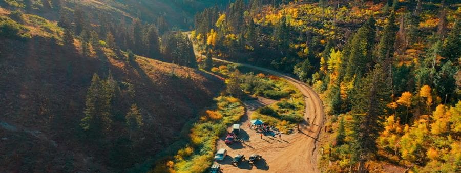
Buckle up! This is northern Utah at its finest.
The DC Peaks 100 is a true mountain ultramarathon, starting in Memory Grove—right below the Utah State Capitol in Salt Lake City—and finishing at Tunnel Springs Park in North Salt Lake. Along the way, you’ll rack up roughly 20,869 feet of vertical gain across some of the best trails the Wasatch Front has to offer.
You’ll head north through foothills and canyons into Davis County, tackling a solid mix of singletrack, service roads, and just a touch of pavement. Grind the climbs, rip the descents, and get yourself properly wrecked before sliding seamlessly into the classic DC Peaks 50 route for the entire back half of the race.
That stretch delivers the goods: the Great Western Trail climb, Mueller Park’s most-loved trails, views that almost make the suffering worth it, and exposed ridgelines that test every ounce of grit you’ve got left.
Expect mostly trail, some service road, and very minimal pavement.
Ultrarunners built this race because we wanted to double down on what matters—killer views, relentless terrain, fantastic people, and a finish line crew ready to meet the runners when it’s all over.
See you kids out there!
- Distance
- 100 miles
- Vertical gain
- ~20,869’
- Start
- Memory Grove, SLC
- Finish
- Tunnel Springs Park
- Time limit
- 36 hours
Sep 30 – Oct 2, 2027
Event schedule
- ThuSep 30
Packet pickup & drop bags
2:00 – 6:00 PM
819 N Lagoon Dr, Farmington, UT
SW side of the building, under the big X.
- FriOct 1
100-mile shuttle
8:30 AM departure
Leaves the finish line (Tunnel Springs Park)
Shuttle transport to the start for 100-mile runners.
- FriOct 1
- SatOct 2
Finish line closes (36-hour limit)
10:00 PM
1080 Eaglepointe Dr, North Salt Lake, UT
Pacers allowed — multiple OK, one at a time
Pacers & crew parking
- Pacers may not start or stop at Francis Peak, Farmington Canyon, Farmington Pond, or Bountiful Peak. We need those roads kept clear of extra vehicles.
- If a pacer needs to drop, they should do so at Farmington Canyon and arrange their own ride down.
East Mtn Wilderness Park · Mile 50
MapGood parking here. Great cell service. If a pacer starts here and doesn’t want to go to Zig Zag, they may drop at Farmington Canyon.
Zig Zag (Parrish Creek Trail) · Mile 80
MapCrew must park down below and walk up. The parking lot will be used as the aid station. Great cell service.
Mueller Park · Mile 85
MapParking along 1800 South. Poor cell service (Verizon is better than T-Mobile).
Summerwood (2) · Mile 95
MapNo crew access. Pacers must be dropped off or picked up from the street at the bottom of the long driveway.
Drop bags, crew, pacers
Aid stations & cutoffs
| Aid station | Mile | Drop bag | Cutoff | Pacer start | Crew vehicle |
|---|---|---|---|---|---|
| Start – Memory Grove | 0 | No | — | — | Yes |
| Summerwood (1) | 10.6 | No | None | No | No |
| Mueller Park (1) | 23.1 | Yes | 7:00 PM Fri | No | Yes |
| Temple Ridge | 28.9 | No | None | No | No |
| Farmington Canyon (1) | 37.5 | Yes | None | No | No |
| Farmington Pond | 43.7 | Yes | None | No | Yes |
| East Mtn Wilderness Park | 49.7 | Yes | 5:00 AM Sat | Yes | Yes |
| Francis Peak | 64.2 | No | 12:00 PM Sat | No | No |
| Farmington Canyon (2) | 68.6 | Yes | None | No | No |
| Bountiful Peak | 72.9 | No | None | No | No |
| Zig Zag | 80.1 | No | None | Yes | Yes |
| Mueller Park (2) | 85.3 | Yes | 5:00 PM Sat | Yes | Yes |
| Summerwood (2) | 94.9 | No | None | Yes | No |
| Finish – Tunnel Springs | 100 | Pick up | 10:00 PM Sat | — | Yes |
Station names with a link open the crew map pin.
Mileage, gain and descent
Segments & profiles
Tap a segment to see its elevation profile.
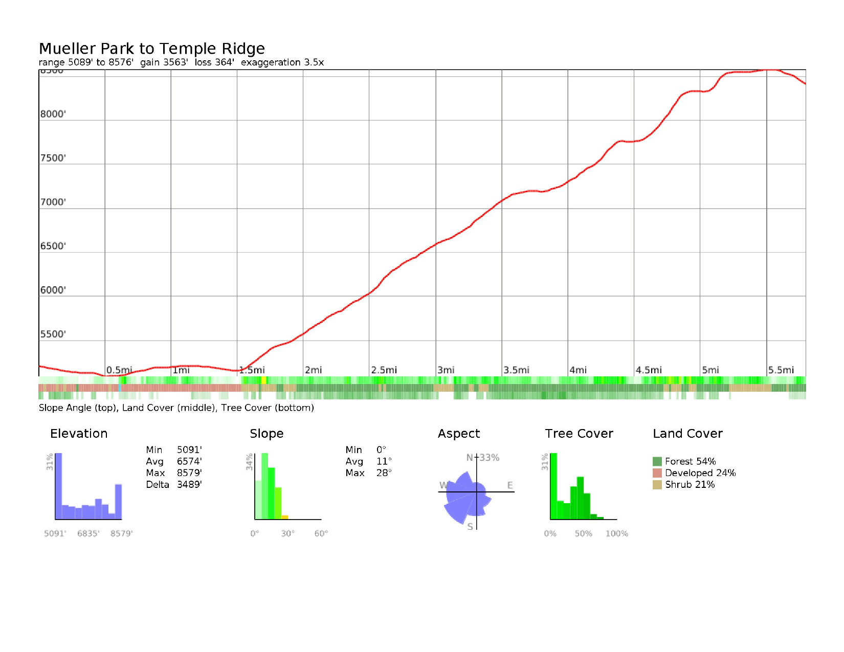
1Start Summerwood10.6 mi · +2,428’ / −1,010’ · mile 10.6
- Segment miles
- 10.6
- Total miles
- 10.6
- Segment gain
- 2,428’
- Total gain
- 2,428’
- Segment descent
- 1,010’
- Total descent
- 1,010’
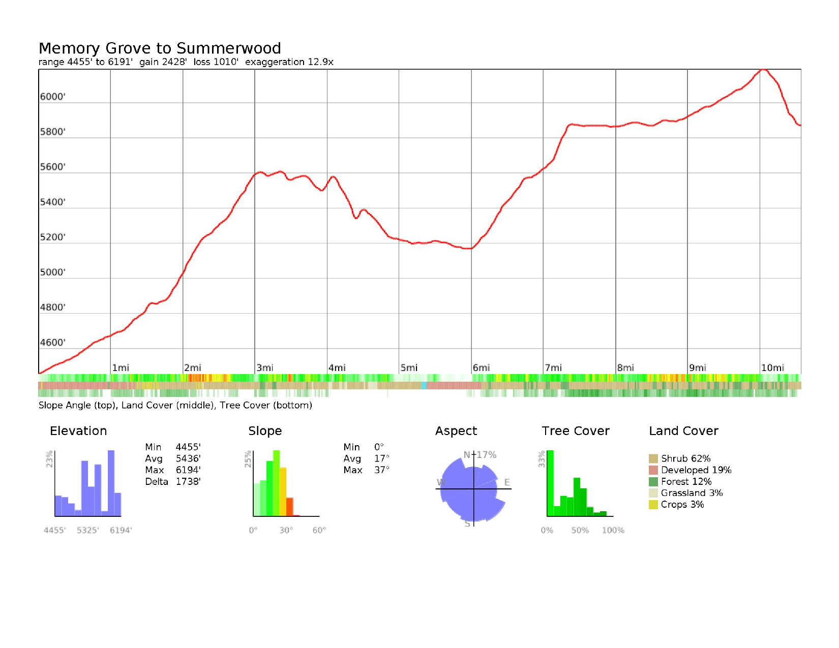
2Summerwood Mueller Park12.5 mi · +1,427’ / −2,090’ · mile 23.1
- Segment miles
- 12.5
- Total miles
- 23.1
- Segment gain
- 1,427’
- Total gain
- 3,855’
- Segment descent
- 2,090’
- Total descent
- 3,100’
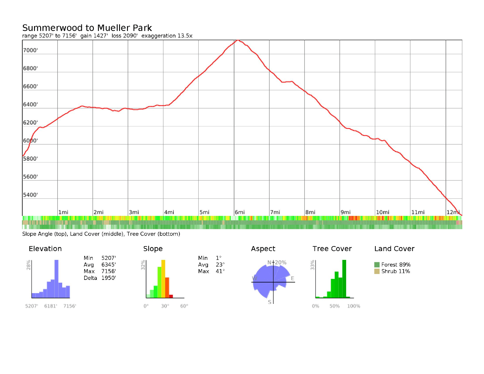
3Mueller Park Temple Ridge5.8 mi · +3,563’ / −364’ · mile 28.9
- Segment miles
- 5.8
- Total miles
- 28.9
- Segment gain
- 3,563’
- Total gain
- 7,418’
- Segment descent
- 364’
- Total descent
- 3,464’
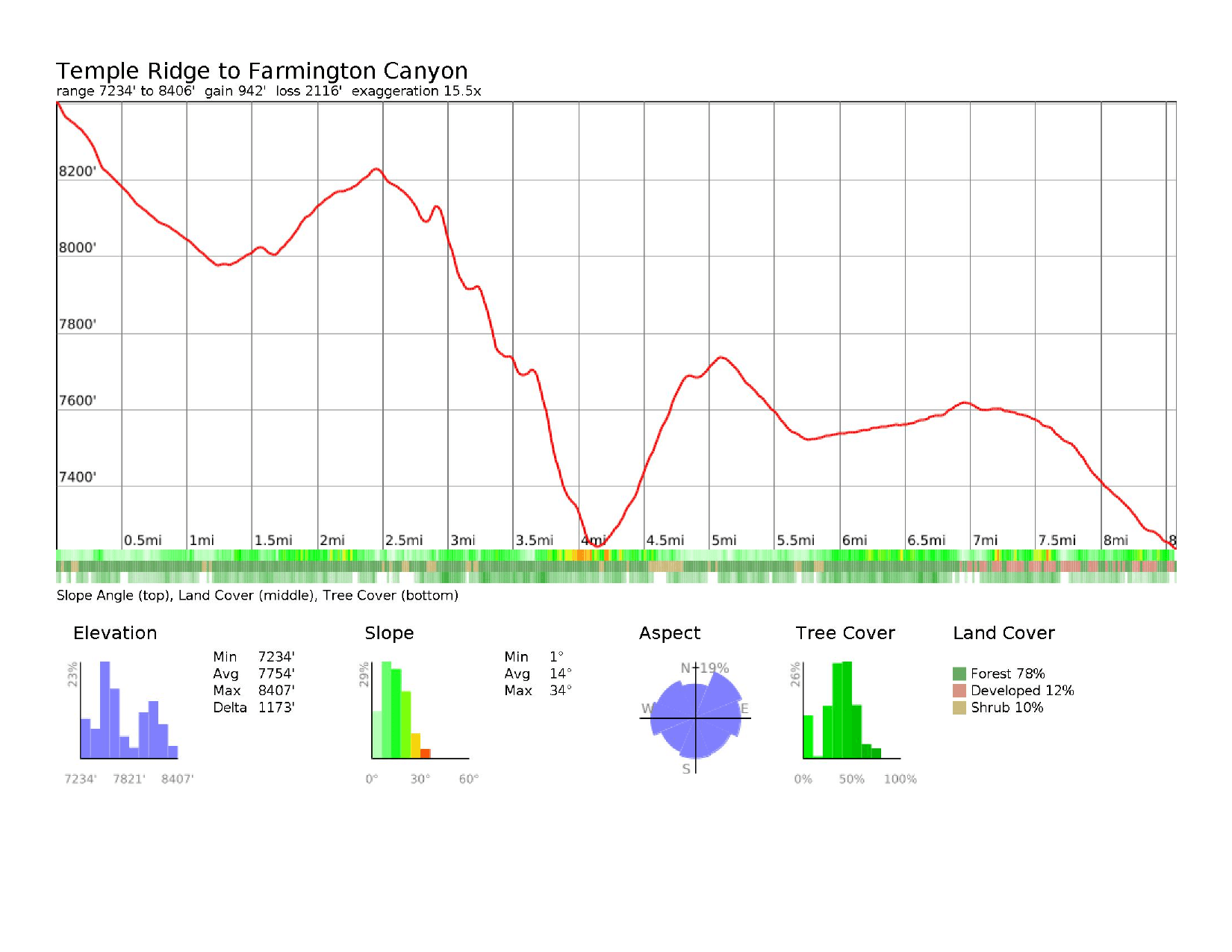
4Temple Ridge Farmington Canyon8.6 mi · +942’ / −2,116’ · mile 37.5
- Segment miles
- 8.6
- Total miles
- 37.5
- Segment gain
- 942’
- Total gain
- 8,360’
- Segment descent
- 2,116’
- Total descent
- 5,580’
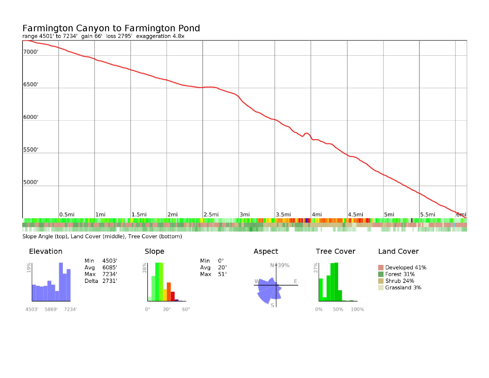
5Farmington Canyon Farmington Pond6.2 mi · +66’ / −2,795’ · mile 43.7
- Segment miles
- 6.2
- Total miles
- 43.7
- Segment gain
- 66’
- Total gain
- 8,426’
- Segment descent
- 2,795’
- Total descent
- 8,375’
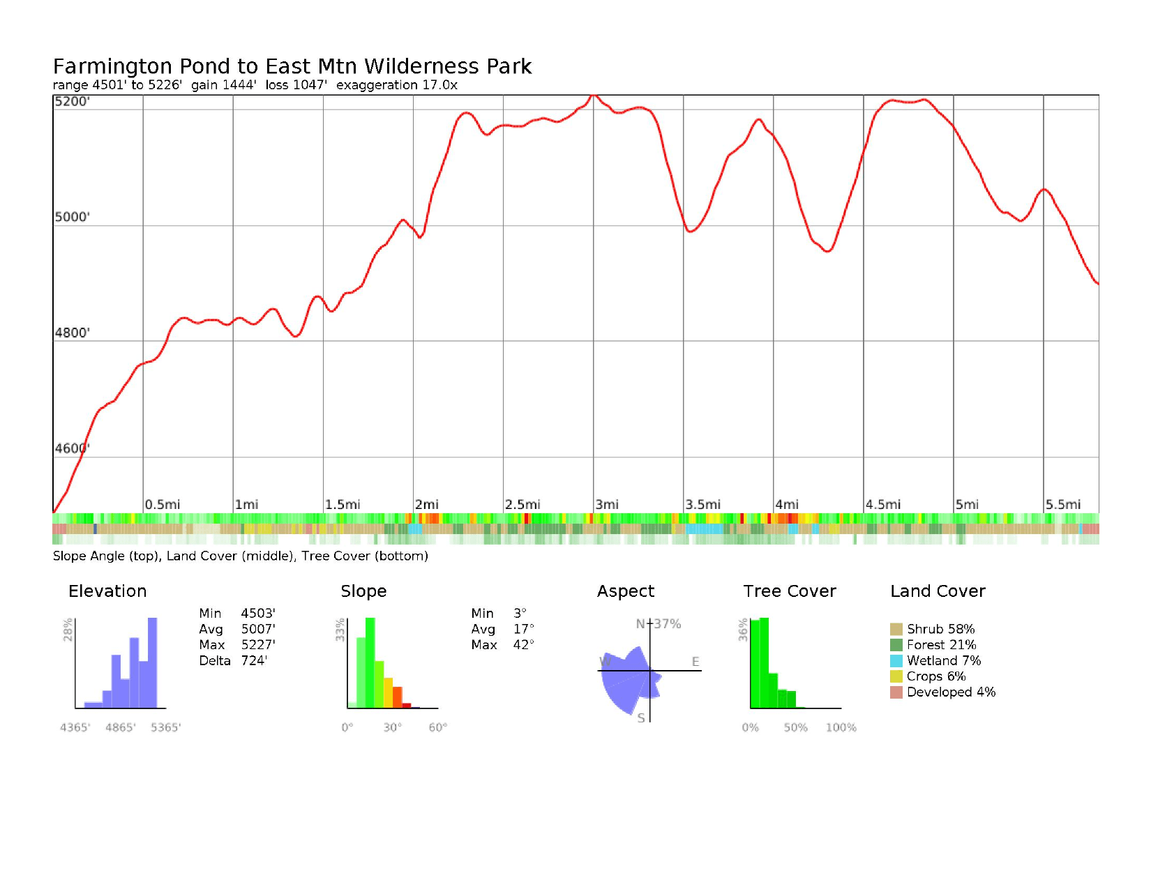
6Farmington Pond East Mtn Wilderness Park5.8 mi · +1,444’ / −1,047’ · mile 49.7
- Segment miles
- 5.8
- Total miles
- 49.7
- Segment gain
- 1,444’
- Total gain
- 9,870’
- Segment descent
- 1,047’
- Total descent
- 9,422’
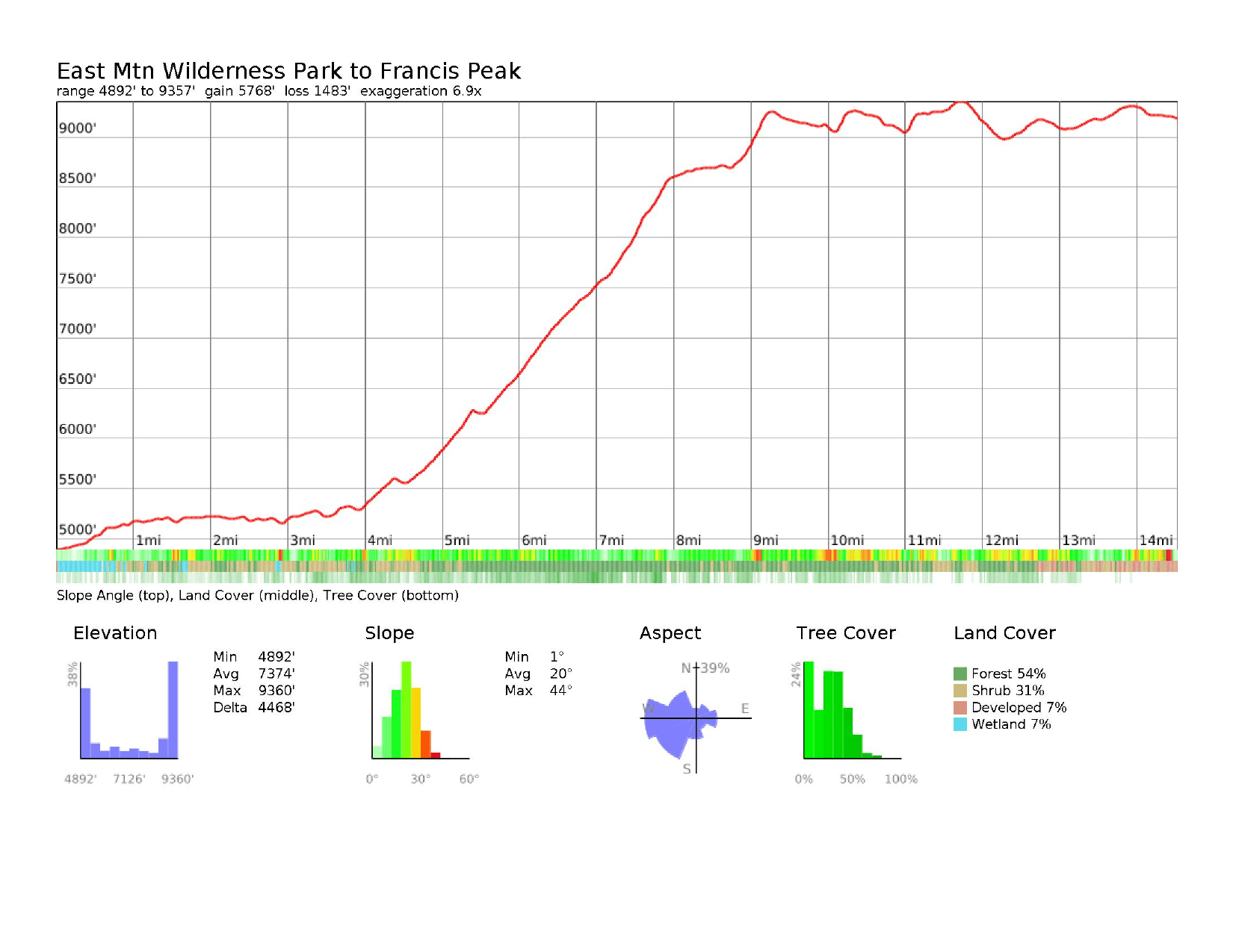
7East Mtn Wilderness Park Francis Peak14.5 mi · +5,768’ / −1,483’ · mile 64.2
- Segment miles
- 14.5
- Total miles
- 64.2
- Segment gain
- 5,768’
- Total gain
- 15,638’
- Segment descent
- 1,483’
- Total descent
- 10,905’
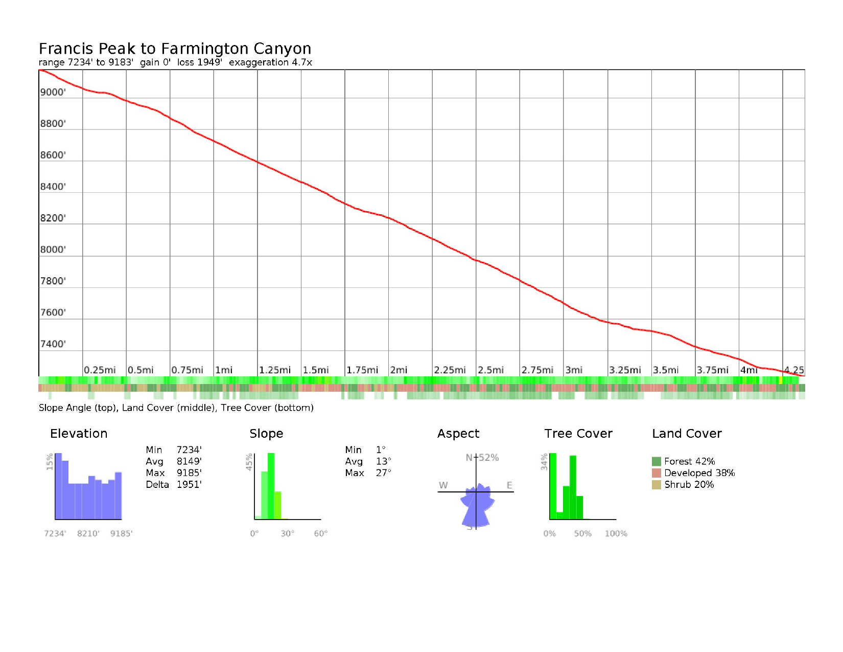
8Francis Peak Farmington Canyon4.4 mi · +0’ / −1,949’ · mile 68.6
- Segment miles
- 4.4
- Total miles
- 68.6
- Segment gain
- 0’
- Total gain
- 15,638’
- Segment descent
- 1,949’
- Total descent
- 12,854’
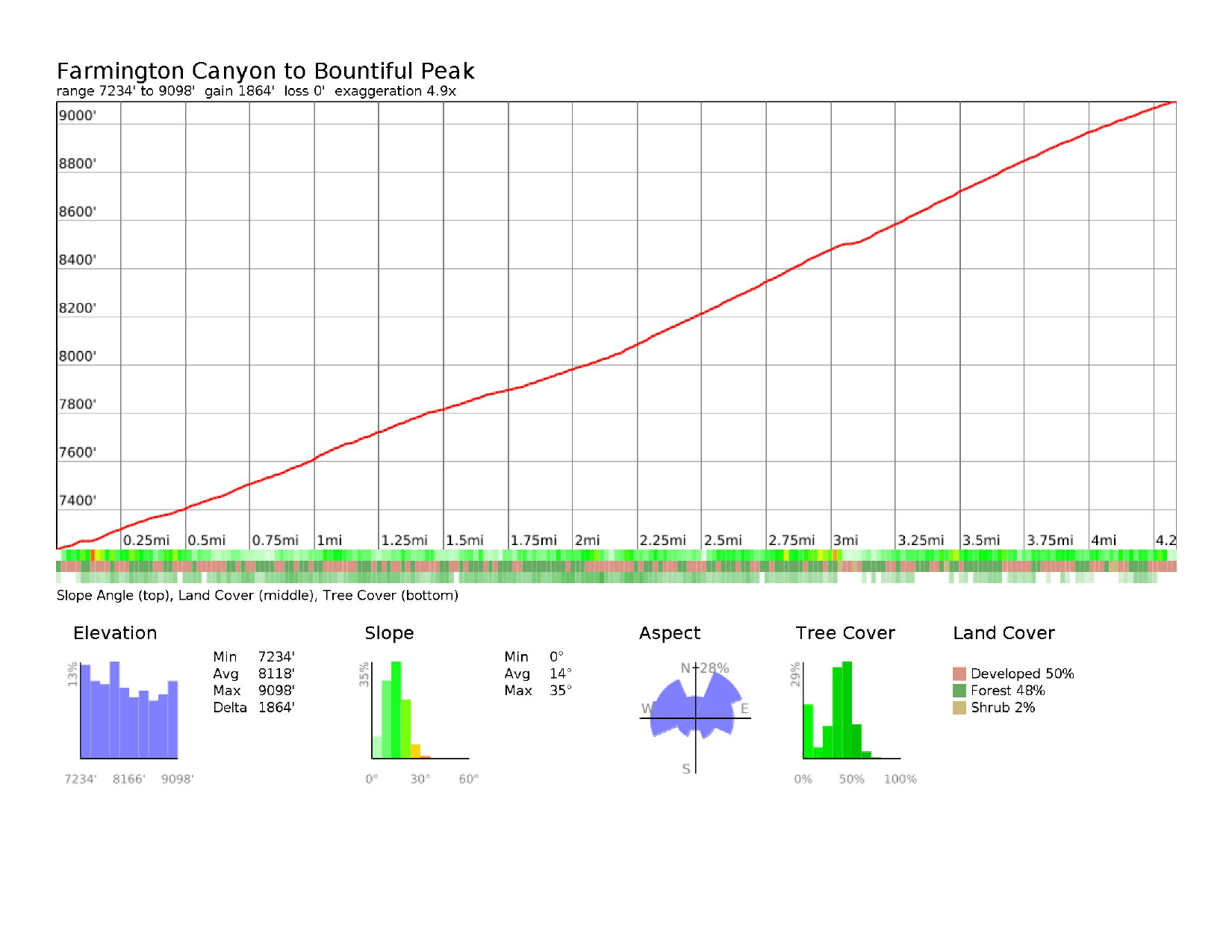
9Farmington Canyon Bountiful Peak4.3 mi · +1,864’ / −0’ · mile 72.9
- Segment miles
- 4.3
- Total miles
- 72.9
- Segment gain
- 1,864’
- Total gain
- 17,502’
- Segment descent
- 0’
- Total descent
- 12,854’
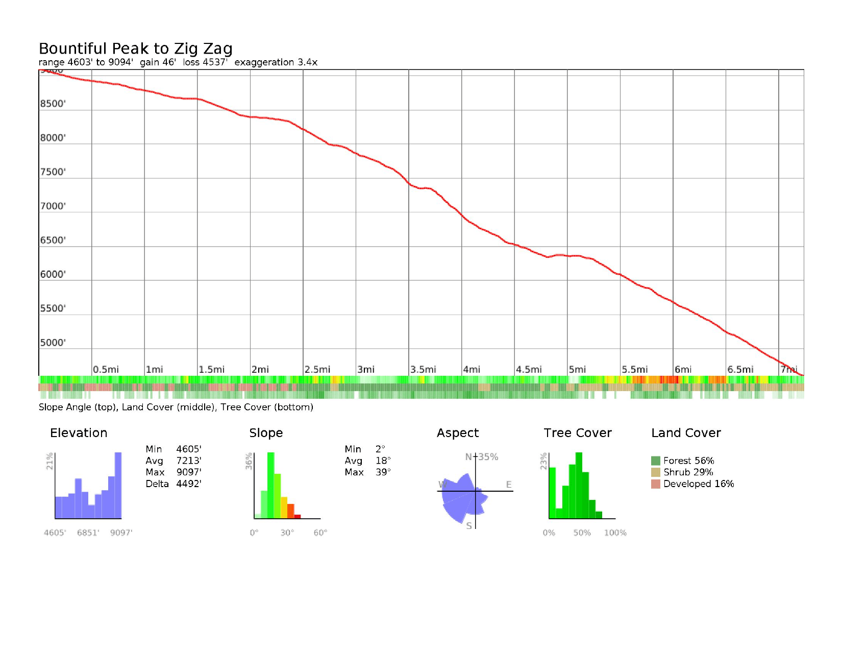
10Bountiful Peak Zig Zag7.2 mi · +46’ / −4,537’ · mile 80.1
- Segment miles
- 7.2
- Total miles
- 80.1
- Segment gain
- 46’
- Total gain
- 17,548’
- Segment descent
- 4,537’
- Total descent
- 17,391’
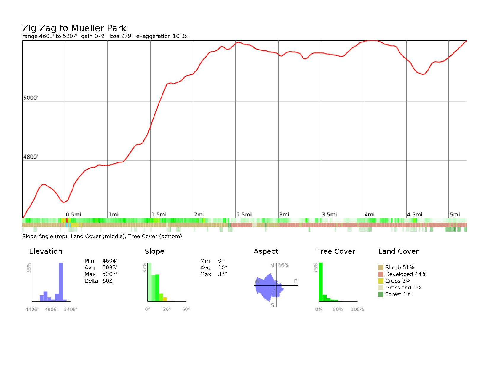
11Zig Zag Mueller Park5.2 mi · +879’ / −279’ · mile 85.3
- Segment miles
- 5.2
- Total miles
- 85.3
- Segment gain
- 879’
- Total gain
- 18,427’
- Segment descent
- 279’
- Total descent
- 17,670’
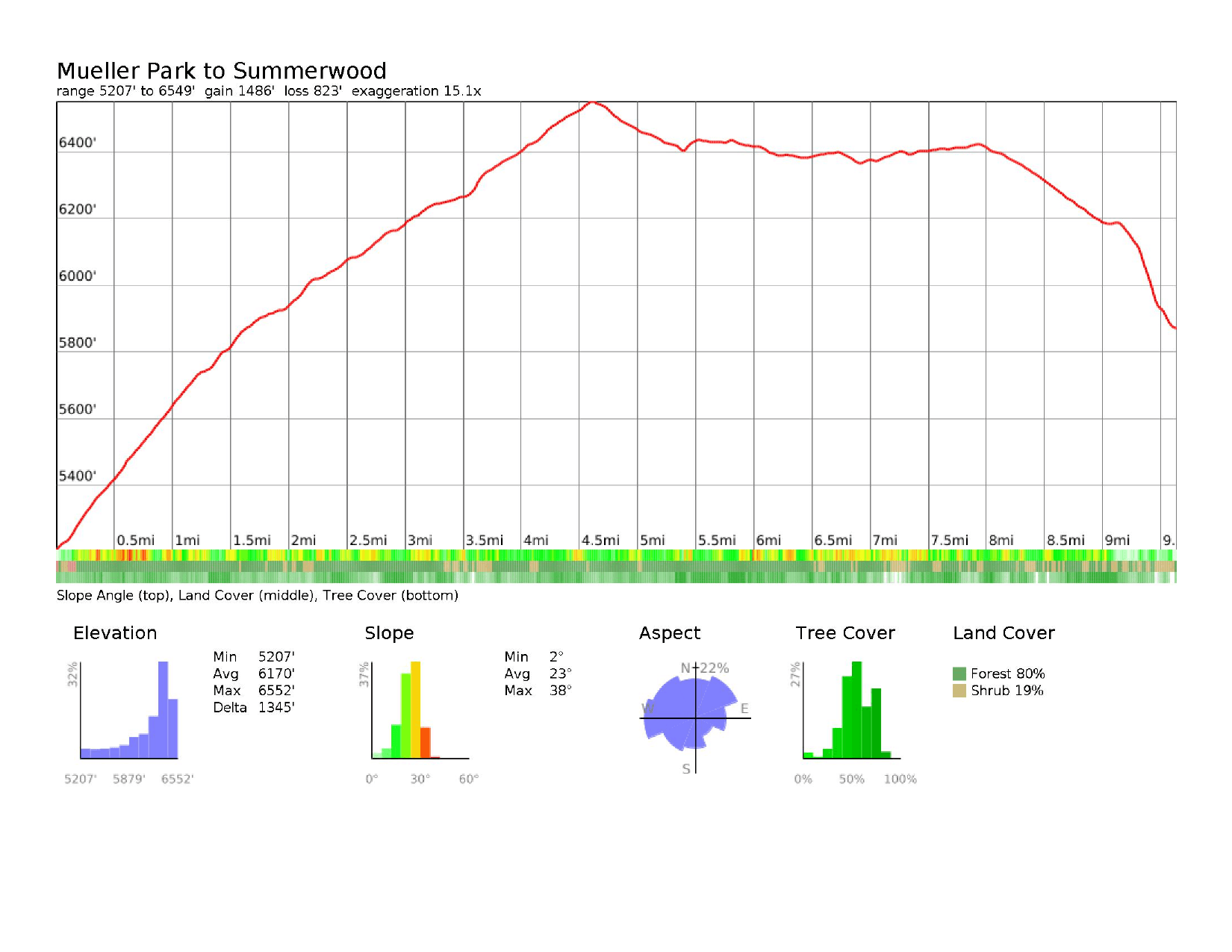
12Mueller Park Summerwood9.6 mi · +1,486’ / −823’ · mile 94.9
- Segment miles
- 9.6
- Total miles
- 94.9
- Segment gain
- 1,486’
- Total gain
- 19,913’
- Segment descent
- 823’
- Total descent
- 18,493’
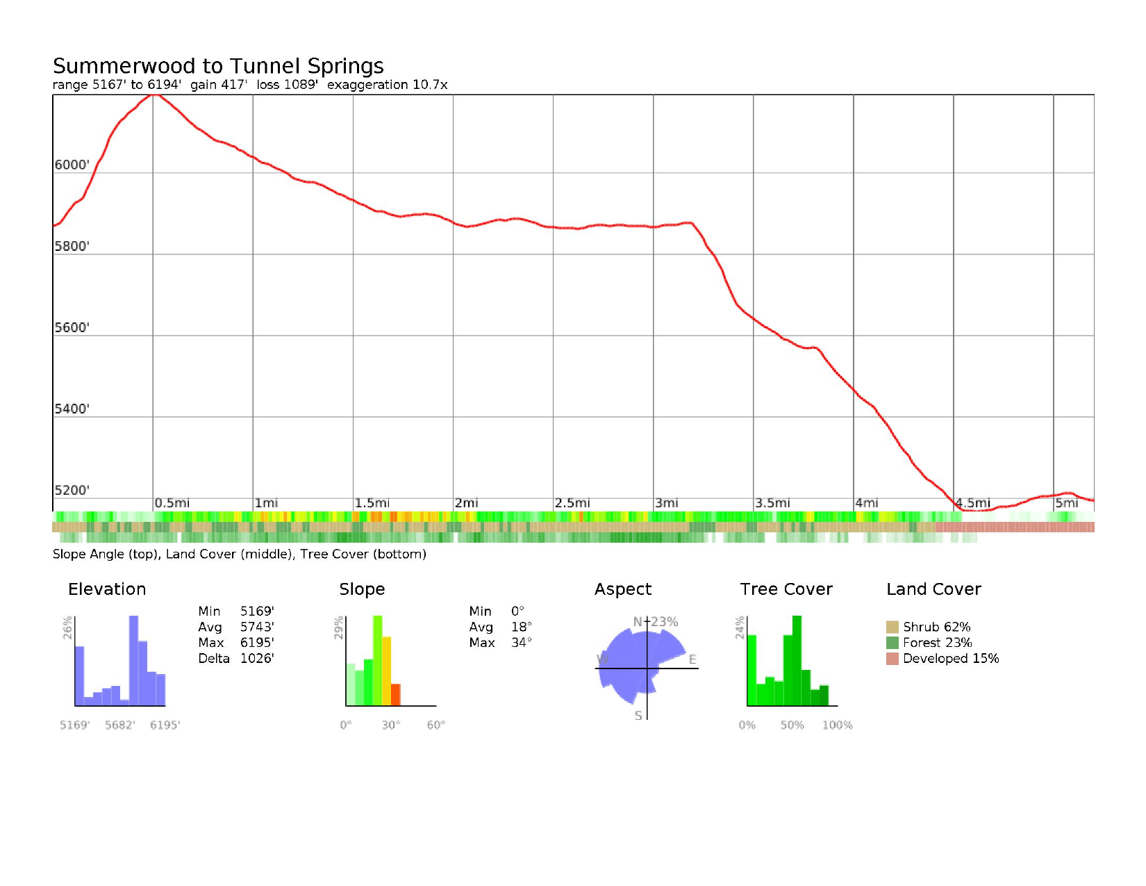
13Summerwood Finish5.2 mi · +417’ / −1,089’ · mile 100
- Segment miles
- 5.2
- Total miles
- 100
- Segment gain
- 417’
- Total gain
- 20,330’
- Segment descent
- 1,089’
- Total descent
- 19,582’
Essential runner information
Course markings
Official course markings
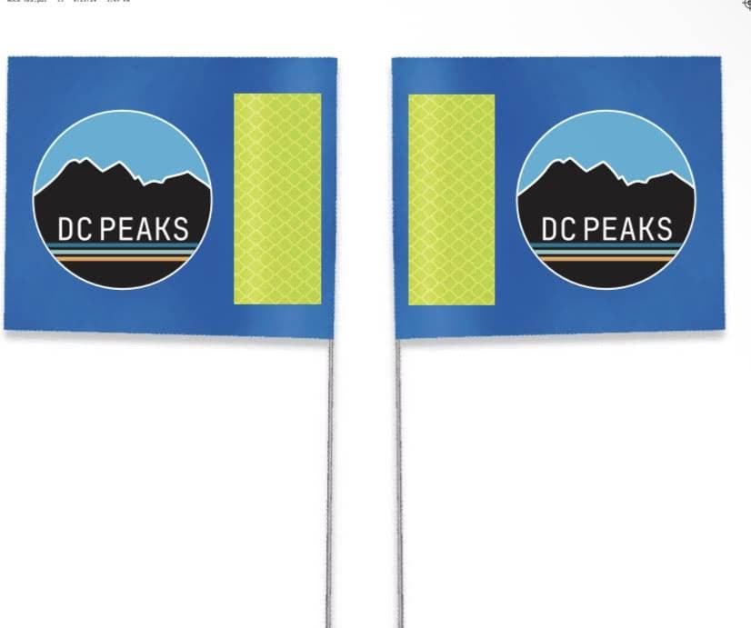
We use blue DC Peaks flags and signs on the course. We do not use any ribbons.
Offline GPX navigation
Download the required GPX navigation file before race day: DC Peaks 100 GPX.
Important trail notice
The “trail police” have removed markings every year, which has caused us to go bald from stress! Do not rely solely on physical flags.
What to expect on course
At the aid stations
Hydration & supplies
- Water & ice
- Electrolyte drink
- Salt tablets
- First aid essentials
- Sunscreen
Quick snacks
- PB&J sandwiches
- Chips & crackers
- Cookies & donut holes
- Fresh fruit & candy
- Pickles
Hot & real food
- Pancakes & bacon
- Quesadillas & pierogies
- Pizza & ramen noodles
- Burgers & hot dogs (select station)
- Warm broth & soup
- Various other real food options!
Essential runner information
Safety & weather
Course safety & rescue
- Side-by-side vehicles are available on course to transport runners off the mountain in emergencies.
- Medical staff are stationed along the course to assist injured runners.
Tracking & navigation
- Runner check-in/out: strict logging at every aid station so we always know your location.
- Mandatory GPX download: download the main and alternate route GPX files before race day. They’re essential for staying on the correct path in remote sections.
Mountain weather
- Weather in the peaks shifts drastically without warning.
- Be prepared for all conditions: extreme heat, freezing cold, rain, snow, and severe wind.
- Check the mountain forecast continuously leading up to race day.
Essential runner information
Medical & emergency
Layton Hospital
201 Layton Pkwy, Layton, UT 84041
801-543-6000Lakeview Hospital
630 Medical Dr, Bountiful, UT 84010
801-299-2200Davis County Search & Rescue
800 West State Street, Farmington, UT
801-451-4100
Dedicated emergency support is available throughout the race.
DC Peaks 100
Race rules & guidelines
1Safety & competition
- Participation in DC Peaks requires strict adherence to all event rules.
- These guidelines are enforced to ensure runner safety, fair competition, and protection of the mountain trails and public lands we use.
- Failure to comply may result in time penalties, disqualification, or removal from the event, at the sole discretion of race officials.
2Course compliance
- Stay on the official marked course at all times.
- Cutting the course or intentionally leaving the marked route may result in time penalties or disqualification.
- The Summerwood Aid Station out-and-back is strictly required. Failure to complete it may result in disqualification.
- Race directors reserve the right to review any off-course incident and determine penalties at their discretion.
- You must check in and out of every aid station.
3Time limit & official finish
- The time limit is 36 hours. Runners must leave Mueller Park (mile 85) by 5:00 PM Saturday.
- If you clear Mueller Park by 5:00 PM and keep making forward progress (no sleeping at Summerwood), an official finish beyond 36 hours is at the race directors’ discretion. Our intent: if you make the Mueller Park cutoff, we will wait for you to finish.
- An official finish means you completed the entire marked course, followed all race rules, passed all aid station cutoffs, and crossed the finish line within the time limit or a reasonable time after making the final cutoff. We don’t like saying someone didn’t finish if they took every step.
4Cutoffs & DNF
- All aid station cutoff times must be observed. Runners arriving after the posted cutoff will not be allowed to continue and will be recorded as a DNF.
- A DNF is recorded when a runner starts but does not complete the full course within the time limit, or withdraws at any point.
- If you withdraw, notify the nearest aid station captain before leaving the course.
5Crewing & self-sufficiency
- Crew assistance is allowed only at designated aid stations.
- Crews must follow all parking, access, and land-use requirements at each location.
- Crews may not provide aid outside of aid stations unless directed by race officials for safety reasons.
- Crew or pacer behavior that creates safety, environmental, or logistical issues may result in penalties or disqualification of the runner.
- Runners must carry their own gear between aid stations. Muling is strictly prohibited.
6Mandatory gear & navigation
- Mandatory gear is not required by default. If weather or safety conditions warrant, requirements may be announced before race day or at packet pickup, and must then be carried at all times.
- A GPX download of the official course is required. Carry a watch or phone with the route downloaded and available for navigation.
- The course is marked, but you are responsible for following the correct route.
7Pre-race check-in
- Complete the pre-race runner check-in. We’ll email you the runner check-in link before race day.
- Check-in and check-out at each aid station is mandatory for tracking.
8Trekking poles
- Optional. Use them or don’t, it’s up to you.
9Dropping & medical
- Notify the aid station captain if you drop. Your bib number and reason will be recorded.
- Runners are responsible for their own transport from the course unless injured.
- Race officials and medical staff reserve the right to remove any runner for safety reasons.
10Headphones & pets
- Headphones are allowed. Stay aware of your surroundings and yield to other trail users.
- Dogs are allowed only from Farmington Pond to Wilderness Park.
- Dogs are welcome at the finish area.
11Leave No Trace
- Littering is strictly prohibited.
- Runners, crews, and pacers must respect public lands and follow Leave No Trace principles. Violations may result in penalties or disqualification.
12Official authority
- Race directors, medical personnel, and officials have final authority on rule interpretation, penalties, disqualification, and runner removal for safety.
Rules for every distance, plus the deferral and cancellation policy, are on the Course Info page.